
Sawitara Trace
Supplier plot register with GeoJSON geolocation, STDB and legality register, EUDR readiness checklist per supplier, deforestation screening results, weighbridge tickets linked to plots, traceability to plantation (TTP), GeoJSON export for DDS, RSPO/ISPO mass balance, grievances and a read API for buyers.
What Trace fixes
Buyers ask for plot geolocation
Exporters and refiners ask for coordinates of every plot of origin, including third-party FFB.
Third-party FFB without origin
Fruit from ramps and collectors arrives without plot records and mixes with fruit of known origin.
Certification credits in spreadsheets
RSPO/ISPO mass balance and credit validity are tracked by hand.
What exists today, and what comes next
Status is stated honestly against the application code.
- Available in the code today and tested
- Preview partly available, with limits stated
- Coming soon planned or in development, not available yet
- AvailableSupplier plot register
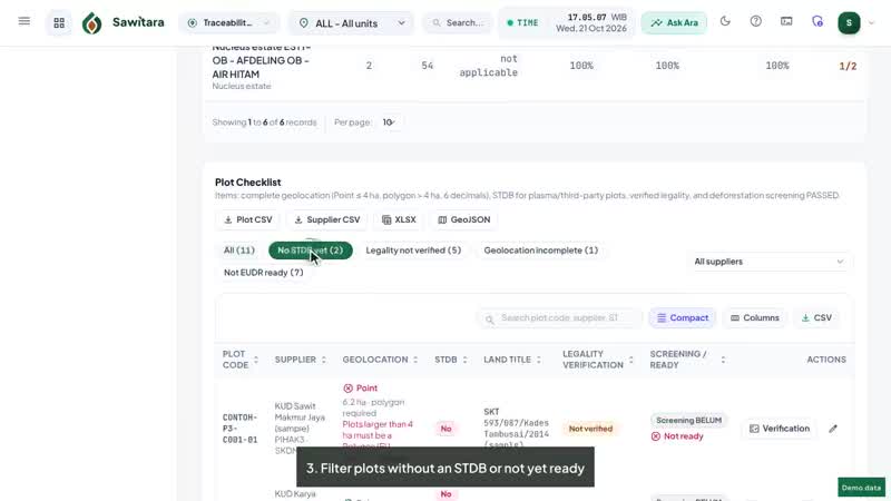
Nucleus, plasma and third-party plots with validated GeoJSON: at least 6 decimals, polygons for plots above 4 ha, closed and non-self-intersecting.
- AvailableSTDB and plot legality register
STDB number, issue date, issuing agency and document; SHM/SKT/HGU land title with validity and document; legality verification by a second officer with a reason when rejected. Deforestation screening results are recorded from other tools or providers, or from EUDR screening against reference layers.
- AvailableSTDB lifecycle and reminders
The STDB status of each smallholder plot (not applied, applied, issued, rejected, revoked) with number, issue date, agency and validity; expiry is calculated automatically. The STDB Reminders tab in PSR & KUR Files lists what needs attention, and Ara · Sentinel checks every morning: expired, expiring soon, applied for too long, rejected or revoked STDB. Issuance stays with the regency office.
- AvailableEUDR readiness checklist per supplier
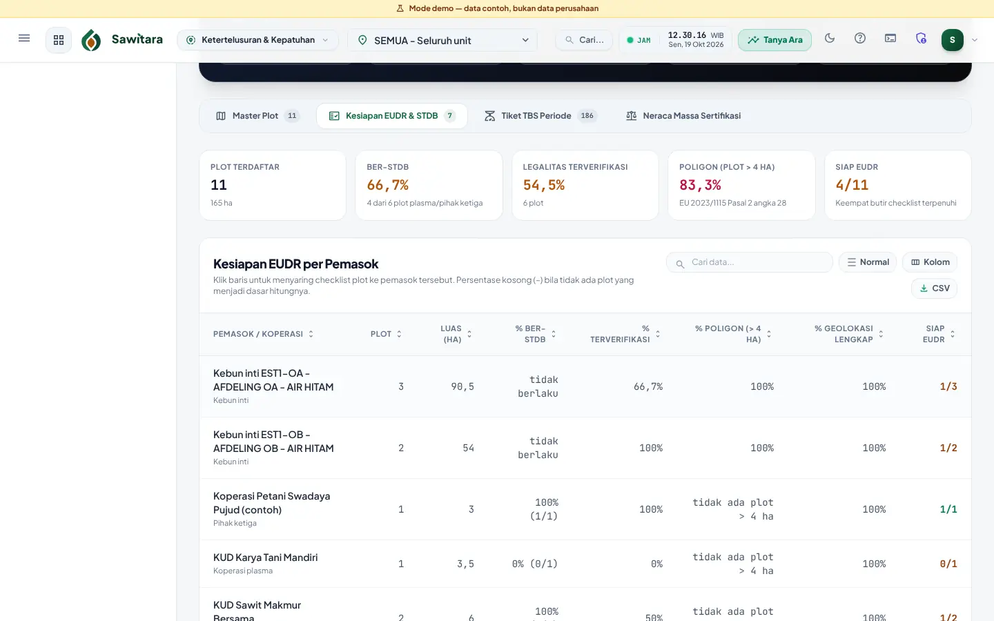
Per supplier or cooperative: plot count, area, share with STDB, share verified and share of polygons for plots above 4 ha; filters for incomplete plots and CSV/XLSX/GeoJSON export.
- AvailableTickets per plot and TTP
FFB tickets and third-party purchases linked to plot codes; period TTP split into nucleus/plasma/third party/unknown, counting only plots that passed screening.
- AvailableGeoJSON export for DDS
The plot list is exported as GeoJSON as input for the buyer’s due diligence statement.
- AvailableCertification mass balance
Credits, claims, balances and validity for RSPO/ISPO schemes.
- AvailableGrievances
Logging and resolution with automatic deadlines and follow-up history.
- AvailableTraceability API for buyers and partners
Token-based read access for buyers or partners chosen by the customer: plots with GeoJSON, STDB and legality status, period TTP, a DDS data pack per DO or contract, and a per-shipment DDS. National ID numbers are masked unless specifically allowed.
- PreviewLot verification via QR on the DO
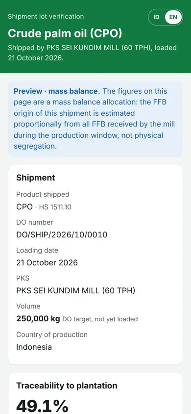
A QR on the CPO/PK DO document opens a public ID/EN page: product, date, mill, volume, share of FFB traceable to plots and EUDR readiness, without supplier, buyer or price data. The mill can revoke the code.
- PreviewPer-shipment DDS (mass balance)
GeoJSON of contributing plots with each plot’s share and allocation for one shipment, computed as a mass balance allocation over the FFB received in the lot’s production window. This is not physical segregation; the method is documented in the API docs.
- PreviewGroup ICS package for ISPO/RSPO
A cooperative internal control system built from data accepted by the mill: member and farm list, map, training, per-member internal inspections, risk register, readiness checklist with the inspection sample, PDF/XLSX/ZIP export. Preparation material, not a certificate and not a certification body audit.
- PreviewEUDR screening against reference layers
Upload forest cover as of 31 Dec 2020, forest/protected area and peat layers (GeoJSON, KML, Shapefile) with source, licence and version; compute each plot’s overlap area, percentage and distance with a No indication, Needs review or Overlap indicated status by your thresholds; officer review with evidence; results feed the readiness checklist. An indication based on uploaded layers, not a deforestation-free claim.
- PreviewDDS GeoJSON for the EUDR Information System
One FeatureCollection per DO per the EUDR GeoJSON File Description (6 decimals, points up to 4 ha, polygons above, ProducerCountry/ProductionPlace/Area) with a format validator and CSV/PDF summary, also via the API. Not yet test-uploaded to the EU system.
- PreviewPSR/KUR files for partners
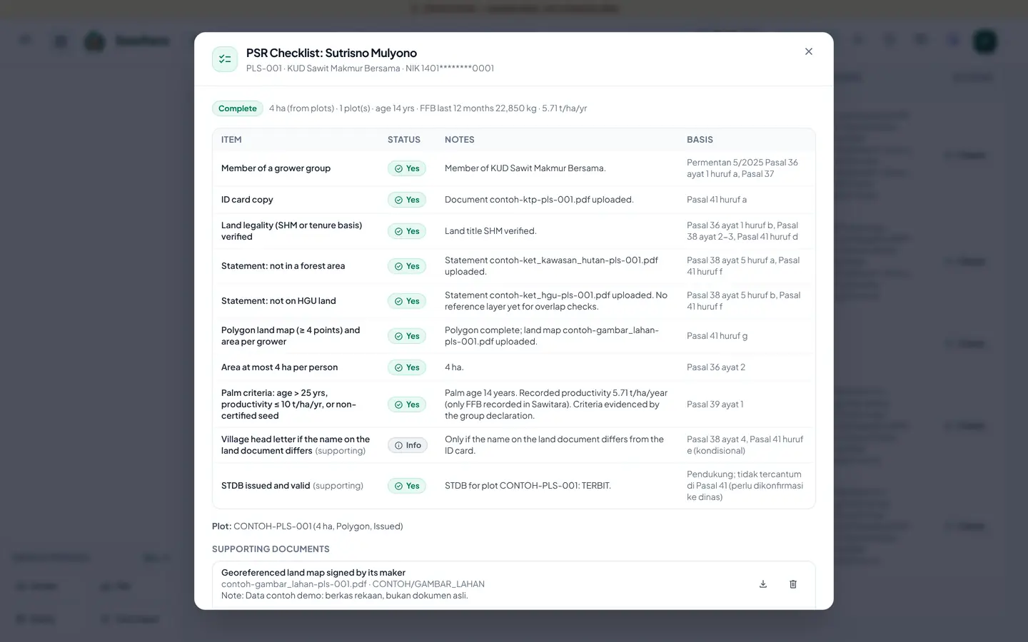
Completeness checklists for PSR replanting (Ministry of Agriculture Regulation 5/2025) and KUR credit per grower and group, computed from plots, legality, STDB, documents and FFB history; dossiers as a summary PDF, attachment ZIP and XLSX/CSV recap. Sawitara only prepares the files; approval rests with the agency, BPDP or bank, with no direct integration.
- Coming soonAuditor access to Trace
A limited access role so a certification auditor or buyer can see traceability data without a full staff account. Not yet available; today data is shared through exports or the token-based read API.
- Coming soonOfficial forms and online submission of PSR/KUR files
Sending files directly to the agency, BPDP or bank depends on their rules and cooperation. Not yet available; today Sawitara only prepares the file package for you to submit yourself.
- Coming soonScreening results import from satellite partners
Receiving deforestation screening results from satellite imagery partners through an API. Not yet available; today results are recorded from the tool or provider you choose, or computed from layers you upload.
- Coming soonDirect DDS submission to the EUDR Information System
Submitting the due diligence statement without a manual upload. Not yet available; today Trace prepares the GeoJSON and summary, and the EU operator submits the DDS.
Honest note: Sawitara does not analyse satellite imagery, is not a certification body and does not guarantee EUDR compliance. The DDS is submitted by the EU operator; Sawitara Trace prepares the supplier data behind it.
Screenshots and video tutorials
Videos are screen recordings of the app with demo data and Indonesian narration.
Who uses it
- Sustainability and compliance teams
- FFB purchasing managers
- Internal auditors and RSPO/ISPO audit preparation
- Buyers and exporters receiving the data
Connected to other products
- Sawitara MillWeighbridge tickets and third-party purchases are the basis of FFB origin, not surveys.
- Sawitara EstateNucleus estate block boundaries are used as plots.
- Tandan by SawitaraRegistered plasma growers and suppliers are linked to their plots.
Quick answers
Does Sawitara Trace guarantee EUDR compliance?
No. Trace records and prepares supplier data (geolocation, legality, screening, ticket chain). Due diligence and the DDS remain the EU operator’s responsibility.
Is there satellite analysis?
No. Screening results are recorded from the tool or provider you choose, or computed as plot overlap with reference layers you upload (preview); Sawitara does not analyse imagery or download datasets itself.
Is one point enough for a small plot?
For plots up to 4 hectares, one point with at least 6 decimals; above 4 hectares a polygon is required. This is validated when the plot is saved.
See Trace with demo data
We walk you through the flow in 15 minutes and answer your team’s questions.